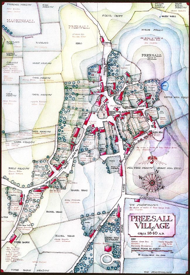
Map 7 Preesall Village in detail, c. 1840 AD

A visitor to modern Preesall from 1840 would easily find his way around, for the layout is little changed, but the old village of cobblestone cottages and thatch roofs is long gone and only a few buildings of that period remain.Striking features are the compact nature of the village, nestling on the west side of the hill sheltered from the cold east winds,and the large number of orchards attached to the dwellings. Carr meadows, in areas below highest tide level, encroach right up to the foot of the hill on the north west.
The two Inns, the Saracen's Head and the Black Bull, with the large farmhouse in between, were the dominant features of the centre, which also contained a number of shops as well as houses, cottages and barns. The Tithe schedule lists the nature, tenant and owner of each one. The Saracen's Head, known locally as " t' Big 'Ead", was owned by the Reverend John Miller, Vicar of Stalmine, who lived in the house at the north end of the village now known as Old Vicarage Farm. The publican was Robt. Miller, probably a relative. The several shops included a blacksmith, a butcher and a shoemaker. The existence of the former wooden peg mill is recorded in the names of Mill Street, Mill Hill and various 'Mill' field names. The school, later moved to the mill site, is still at the bottom of the hill at the north end of School Brow, known as "Skoo Broo".
The Tithe Barn at the bottom of Back Lane comes with a list of the tithe proprietors to whom the vicar had obviously sold the right to collect tithes, a common practise which demonstrates the breakdown of the system. Cornelius Bourne, of an eminent local landowning family, was occupying the elegant late Georgian country house called Fern Hill Cottage.
The ancient Fairy Well, now just a muddy patch, was still existing and was actually the source of the Hackinsall watercourse which crossed the road at Ford Stones, under a bridge by 1840, joining the Wyre at Geoffrey's mill site. The steep north end of the hill, now covered by trees and undergrowth, was then completely bare and remained so for at least another 60 years or so.
The computer screen does not do justice to Gordon's maps. If you would like to obtain your own high resolution copy follow this link for the details: High Resolution Maps.
More maps

Return to the Map Index Page.
 IrfanView.